As wildfire season approaches, ai could pinpoint risky regions using satellite imagery | techcrunch
As wildfire season approaches, ai could pinpoint risky regions using satellite imagery | techcrunch"
- Select a language for the TTS:
- UK English Female
- UK English Male
- US English Female
- US English Male
- Australian Female
- Australian Male
- Language selected: (auto detect) - EN
Play all audios:
The U.S. has suffered from devastating wildfires over the last few years as global temperatures rise and weather patterns change, making the otherwise natural phenomenon especially
unpredictable and severe. To help out, Stanford researchers have found a way to track and predict dry, at-risk areas using machine learning and satellite imagery. Currently the way forests
and scrublands are tested for susceptibility to wildfires is by manually collecting branches and foliage and testing their water content. It’s accurate and reliable, but obviously also quite
labor intensive and difficult to scale. Fortunately, other sources of data have recently become available. The European Space Agency’s Sentinel and Landsat satellites have amassed a trove
of imagery of the Earth’s surface that, when carefully analyzed, could provide a secondary source for assessing wildfire risk — and one no one has to risk getting splinters for. This isn’t
the first attempt to make this kind of observation from orbital imagery, but previous efforts relied heavily on visual measurements that are “extremely site-specific,” meaning the analysis
method differs greatly depending on the location. No splinters, but still hard to scale. The advance leveraged by the Stanford team is the Sentinel satellites’ “synthetic aperture radar,”
which can pierce the forest canopy and image the surface below. “One of our big breakthroughs was to look at a newer set of satellites that are using much longer wavelengths, which allows
the observations to be sensitive to water much deeper into the forest canopy and be directly representative of the fuel moisture content,” said senior author of the paper, Stanford
ecoydrologist Alexandra Konings, in a news release. The team fed this new imagery, collected regularly since 2016, to a machine learning model along with the manual measurements made by the
U.S. Forest Service. This lets the model “learn” what particular features of the imagery correlate with the ground-truth measurements. They then tested the resulting AI agent (the term is
employed loosely) by having it make predictions based on old data for which they already knew the answers. It was accurate, but most so in scrublands, one of the most common biomes of the
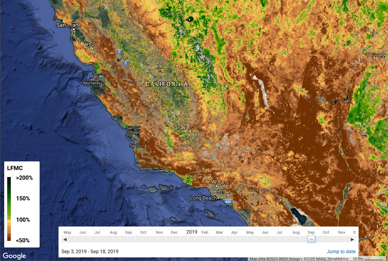
American west and also one of the most susceptible to wildfires. You can see the results of the project in this interactive map showing the model’s prediction of dryness at different periods
all over the western part of the country. That’s not so much for firefighters as a validation of the approach — but the same model, given up to date data, can make predictions about the
upcoming wildfire season that could help the authorities make more informed decisions about controlled burns, danger areas and safety warnings. The researchers’ work was published in the
journal Remote Sensing of Environment.
Trending News
Breakfast host bill turnbull clumsily jokes about weather girl carol kAs curvy Kirkwood presented the weather, her 58-year-old colleague jokingly told her that there was a "lot of inter...
The big bang theory: leonard star set for major reunion in new sitcomBig Bang Theory actor Johnny Galecki, who played Leonard in the hit series, is taking on a role in The Squad which will ...
Beating retreat ceremony 2023: india's biggest drone show mesmerises spectators at delhi's vijay chowkBEATING RETREAT CEREMONY 2023: FOR THE FIRST TIME, A 3-D ANAMORPHIC PROJECTION WILL BE DONE ON THE FACADE OF NORTH BLOCK...
Bolivia takes chile to court over access to seaLandlocked Bolivia is turning to the International Court of Justice in The Hague to reclaim access to the sea that it lo...
Dodger defeat high in priorityCHICAGO — Mark Prior is one of baseball’s most dominant young pitchers, his prowess evident in the three blazing fastbal...
Latests News
As wildfire season approaches, ai could pinpoint risky regions using satellite imagery | techcrunchThe U.S. has suffered from devastating wildfires over the last few years as global temperatures rise and weather pattern...
Marketwatch metrics - marketwatchIntraday Data provided by FACTSET and subject to terms of use. Historical and current end-of-day data provided by FACTSE...
“is it okay when my teacher or parents hits me? ”Sameera Ahmed | The News Minute | September 9, 2014 | 6. 11 pm ISTIt is a common sight in India – a parent beating up hi...
2019 AARP Livable Communities Placemaking Workshop- Keynote Address- Matthew Lister29:33 AARP Videos Livable Communities 2019 AARP Livable Communities Placemaking Workshop- Keynote Address- Matthew Liste...
Evidence based treatments | veterans affairsWe now have effective treatments for a range of mental health conditions that, not long ago, were considered untreatable...